Chaparral Golf Adventures, Caminito del Rey
One of the most beautiful and exciting trails in Spain!
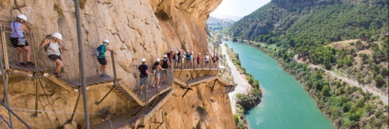
Caminito del Rey is breathtaking and exciting with narrow boardwalks, a hanging footbridge that stands at 105 metres height and steep mountain walls; much more than just a path in the mountains!
Before the recent restoration, Caminito del Rey, an 8-kilometre path on the cliff of a mountain near Malaga (Andalusia) was considered to be one of the most dangerous in the world. Today the entire route has been carefully restored, receiving the European Nostra Award for heritage conservation, and although it’s now much safer, one thing hasn’t changed – the unique experience of strolling along walkways hanging over 100 metres up on a sheer cliff face. Take one of the best selfies ever. You’ll never forget the views!
How long is the path?
The full length of El Caminito del Rey is 7.7 km. The part of the access ways is 4.8 km long and the stretches between the entrance and exit gates of the boardwalks.
How long do you take to finish the route?
The boardwalks are the most famous part of the path.
The distance between the entrance and the boardwalks next to the control cabin and its exit is 2.9 km. This part comprises 1.5 km-long boardwalk and 1.4 km-long path or forest trail. Nevertheless, there is to add a few km from the northern or southern entrance to the control cabin. The estimated time to do the whole route is three to four hours.
The route El Caminito del Rey is linear, so you must take into account the time you need to go back to the starting point, checking previously the timetables of buses and routes.
How do I get there?
You can come by train or by road.
If you choose the train, RENFE train service offers regional trains on daily basis to El Chorro.
The access road from Málaga to the path is the A-357, which is in good condition up to the Zalea crossroad.
From there you can go along the same road to Ardales, or take the exit MA-5403 and go towards M-442 up to El Chorro. This road goes through a lush pine wood and around the Conde de Guadalhorce Reservoir. Your other option is to follow the A-343 road up to the crossroad at Pizarra and A-7077 that leads to Álora – El Chorro.
Álora is 12 km away from El Chorro if you follow the road that goes up the Guadalhorce River. It is surrounded by beautiful landscape, wide orange or lemon trees orchards, and small hills with olive and almond grove in the higher zones. This is a curvy road but it offers magnificent view of the scenery above all during the flowering season when orange, lemon and almond trees become stunningly beautiful. This way goes through the small villages of Caracuel and Bermejo (where you can find restaurants, a chemist, a tobacconist’s and grocery stores) to El Chorro village where varied services are provided such as train station, shuttle bus stop where you can take the bus to the northern entrance to El Caminito del Rey, the Tourist Office, the Reception Centre, a car park, as well as restaurants and accommodation.
Info, prices and opening hours?
Timetables, opening dates and possible changes and modifications are published on the website where the entrances tickets to Caminito del Rey are acquired with entrances every 15 – 30 minutes Tuesday – Sunday.
Book your summer break! : www.golfelchaparral.com/en/book-online
Info & Bookings: http://www.caminitodelrey.info/es